
Is it time to love Rte. 18?
By Steven Froias
Groundworker-At-Large
When it was completed in the early 1980s, The Standard-Times immortalized Rte. 18’s terminus at Cove Street with the headline, “Highway to Nowhere?”
Partially designed to alleviate the traffic that clogged south end streets at quitting time, many of the mills and manufacturers in this area of New Bedford had shuttered or substantially reduced their workforce by the time work was completed. The problem had largely “solved” itself.
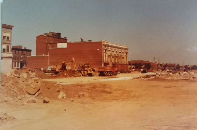
Final construction of Rte. 18 – the John F. Kennedy Memorial Highway – is pictured in this file photo from the early 1980s. The Orpheum Theater overlooks what was once Water Street.
On the course to finding a solution – and guided by the “urban renewal” policies of the time – bringing Rte. 18 to the south end of New Bedford disrupted a part of the city full of emotional infrastructure.
Eminent domain bulldozed through a residential, largely Cape Verdean, neighborhood. And, the final, faded remnant of the commercial corridor of Water Street was essentially obliterated by what was officially called the John F. Kennedy Memorial Highway at this end of Rte. 18.
For many residents, in the south end and elsewhere, Rte. 18 has been a roadway of derision. A scar across the landscape which separated the city from its own waterfront, destroyed the fabric of community and literally ran over too much of New Bedford’s architectural heritage in the process of its creation.
And that’s largely been the perception of Rte. 18 ever since – an urban evil to be borne but never embraced.
Yet generations later, with a renewed focus on neighborhood health throughout the city, a nascent wind-energy industry centered just off the highway at the New Bedford Marine Commerce Terminal, and a still-thriving fishing industry for which transportation is critical, is it time to finally love Rte. 18?
There’s a lot of reasons to re-think the roadway everybody loves to hate.
Here’s a few of them:
THE REDESIGN AT THE FOOT OF UNION STREET has worked. Balancing the needs of industry, recreation and tourism was no easy task. However, the redesign of the stretch of Rte. 18 centered at the foot of Union Street and reaching down to Walnut Street and up to Elm Street has been a significant improvement. An abysmal situation has been made manageable for both vehicular and foot traffic. Is it perfect? Of course not. Then again, few such congested urban areas seldom are anywhere.
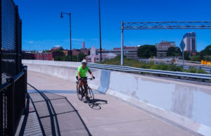
The bike and pedestrian pathway to the Fairhaven Bridge has created a quintessential urban space.
THE PEDESTRIAN/CYCLING APPROACH TO FISH ISLAND, Fairhaven Bridge and Pope’s Island beyond created by the redesign is a one-of-a-kind, quintessential urban space. It’s not unlike the Brooklyn Promenade across from lower Manhattan, built to accommodate Robert Moses’s Brooklyn-Queens Expressway. There’s something empowering for the pedestrian or cyclist to literally rise above the traffic on the highway below and make their way up to the bridge and what photographer and artist, Brandon Cabral calls “East New Bedford.” Beautiful views of the city’s fishing fleet, historic harbor and Fort Phoenix await. The new playground on Pope’s Island has proved popular, activating the space defined not just by the view but a magnificent statue of Prince Henry the Navigator. And, the Fairhaven bike path beckons after crossing the bridge…
LOWER RTE. 18 IS BEING TRANSFORMED INTO A TRUE BOULEVARD – and it’s an amazing transformation. Back where we began, where Rte. 18 becomes what’s now the John F. Kennedy Boulevard, MassDOT, in partnership with the City of New Bedford, is in the final stages of completing an overhaul of the roadway which finally addresses its original sin. An ample new pedestrian and cycling path running right along the boulevard helps integrate into into the surrounding neighborhood, as do new means of egress and entry from nearby streets. Graceful lighting runs down the center and gives this stretch of pavement a touch of bling. Most of all, it finally connects rather than divides the city. A walk alongside Rte. 18 reveals just howclose the downtown and south end actually are, and functions so well that the delights of the south end’s peninsula are finally introduced into the larger conversation of the city.
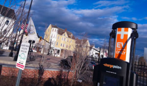
The lot and charging stations at Coggeshall Street are a landing stage for the Acushnet Avenue commercial corridor.
IT’S THE GATEWAY TO ACUSHNET AVENUE AND THE NORTH END, and the groundwork for the future has been laid at Coggeshall Street. The public parking lot where Rte. 18 meets Coggeshall Street is something every municipality should have in its toolkit. It’s a large lot, complete with charging stations for electric cars, that sits just outside a dense commercial corridor percolating with new life. Within blocks of it, restoration will begin soon on the Strand Theater, turning it into a Cape Verdean Cultural Center and public park. Coggeshall Street itself, home to beloved eateries Endzone, Antonio’s and The Dog House, has just been widened and resurfaced. Delivering patrons to this rising, relentlessly urban space is…Rte. 18.
In the final analysis, Rte. 18 is something more than a roadway. It’s a Rorschach test for how people view the City of New Bedford. The journey to a fully-functional future may have been bumpy, but it’s happening now and you can see it reflected in the history of this highway through the city.
In a creative city, Rte. 18 just may be the most epic placemaking project ever undertaken here.
It has taken a while to reach the end of the road, but many decades after the first asphalt was spread, it may finally be time to love Rte. 18 – and move forward.

- A Pride month to be proud of in New Bedford - May 30, 2019
- OUTTAKE: Inside the First Baptist Church renovation - May 2, 2019
- New Bedford Economic Development Council’s Spring Fling - April 30, 2019